Dechmont Training Area (DTA) and Live Firing Ranges are operated and managed by Lowland RFCA on behalf of the Ministry of Defence.
Video shows Dechmont Range and Training Area in use by the Army Cadet Force.
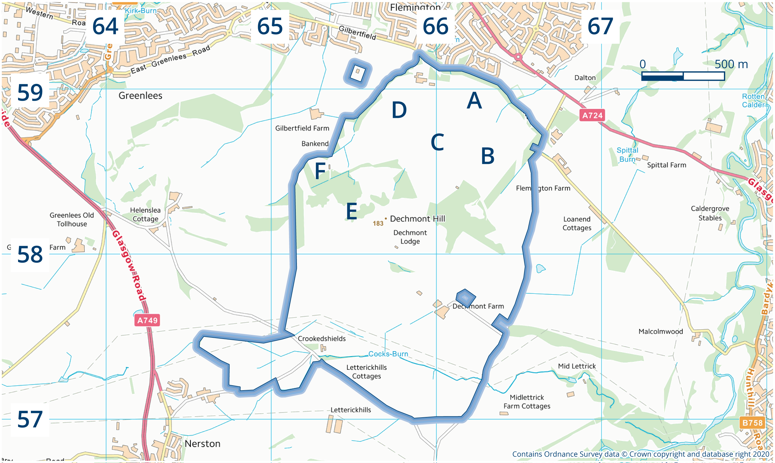
Eight miles south east of Glasgow city centre, Dechmont comprises 627 acres of which 214 acres are routinely available for low level training, including a 25m Barrack Range, while two thirds (including a working farm) are let to a farmer.
Dechmont Training Area Users
DTA and its ranges can be booked for training by:
Regular units/organisations
Reserve units/organisations
Cadet units/organisations – SCC, ACF, ATC & CCF
Booking requests will also be considered from:
Other Government Departments e.g. Police and other emergency services
Other users through the Alternative Venues initiative e.g. Civilian Rifle Clubs and other organisations
Facilities
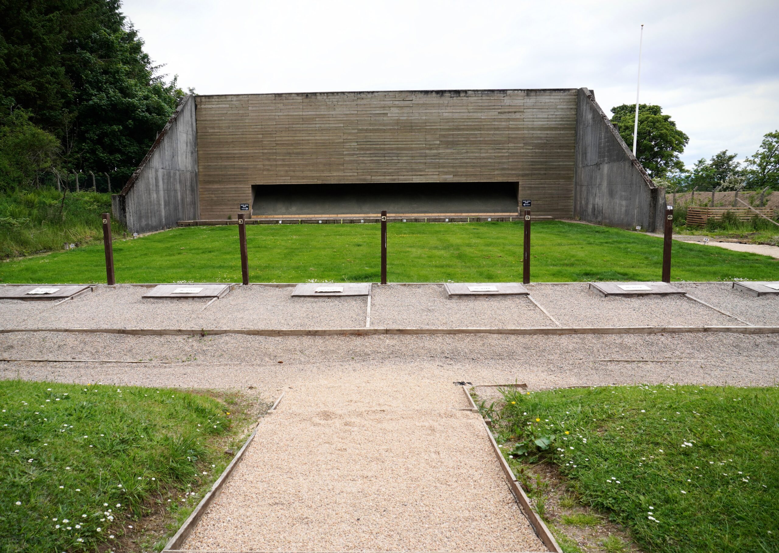
6 Lane 25m NDA Barrack Range
Clay-pigeon Range
Archery Range
Dry Training Areas A, B, C, D, E and F, all suitable for low-level Fieldcraft and Navigation Lessons
Area A – Currently leased and in use by local farmers
Area B – Currently leased and in use by local farmers
Area C – Expanse of low-lying grass land, suitable for all Types of Dry Training
Area D – Live Firing and DTA area D Incorporates the Clay-Pigeon and Archery Range Area D can be used for dry training when Live firing or Archery is not taking place.
Area E – Incorporates the high ground of Dechmont hill (183m), excellent ground for Map work, OP’s or unit TEWT’s
Area F – Live Firing 6 Lane 25M NDA Barrack Range with surrounding grassland and wooded areas suitable for dry training and concurrent activity while the range is in use
Range Control Compound – Offers Users the following facilities:
Classroom
Toilet facilities
2 outbuildings (Useful for Unit Stores)
Hard standing for parking
Accommodation cannot be booked or guaranteed through the DTA booking process. However, there is limited accommodation available at the neighbouring Cadet Training Centre – Glasgow and Lanarkshire Battalion Army Cadet Force HQ. Whilst not guaranteed, the Range Manager would be happy to discuss your accommodation needs and can put you in touch with the appropriate person to explore this further.
To find out more about the range, feel free to browse the documents on the right-side of this page.
Public Access
All areas are used by the public under the Scottish Outdoor Access Code (SOAC) for walking, cycling and horse riding. Grazing rights have been granted to local farmers, these considerations are key to successful planning. Current Information on how this may affect training plans can be discussed with the Range Manager.
Directions
Click here to get Dechmont Directions
History
Dechmont was developed in the late 19th century as a range complex to service the burgeoning Rifle Volunteer Corps which had been established across the UK in the 1860s. By 1939, there were four 400 to 600-yard gallery ranges, two additional ranges and a Territorial Army (TA) camp, all catering for Glasgow’s many TA units. Firing was from the northern area into stop butts situated at the foot of Dechmont Hill, which rises from 100m to 180m, while what is now given over to farmland on the southern side of Dechmont Hill, constituted the Range Danger Area.

